Langtang Gosainkund Helambu(from 04.11.2020 to 20.11..2020)

All Inclusive Price

6% Off

Trip Overview

Level 11/20 13 days of trekking at a maximum altitude of 4984m. Average daily stages of 5 to 6 hours.

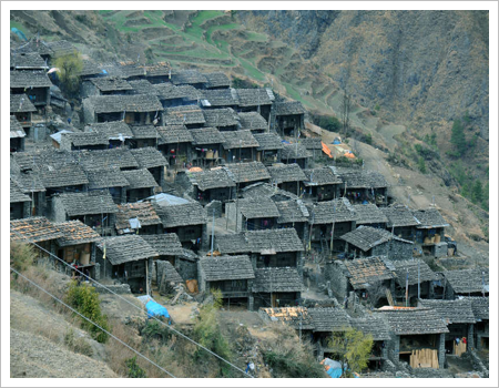
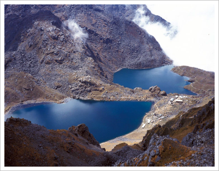
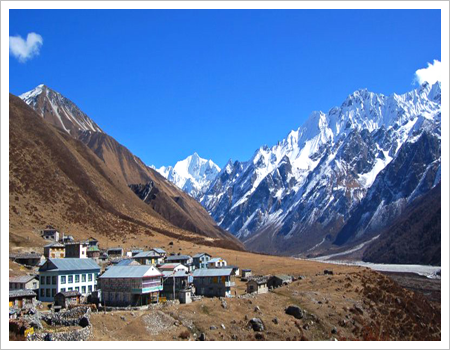
This trek in the northern Kathmandu region is accessible by road and combines the three main areas of the Langtang Valley, the Gosainkund Lakes, and the Helambu Hills. The Langtang Valley lies between the Langtang massif to the north, just below the border with Tibet, and the smaller peaks of Naya Kanga and Ganjala Himal to the south. This remote valley is inhabited by the Tamang people, the second largest ethnic group in Nepal, whose religious practices, language, and traditional dress are very similar to those of Tibet. Access is by road to Shyabru Besi, and from there, in stages of moderate length to avoid a sudden ascent, we ascend the right bank of the Langtang Khola valley to the last village, Kyangjin Gompa, at the foot of Langtang Lirung (7227m). From this village, we climb either Tsergo Ri or Kyangjin Ri, small but easily accessible peaks of nearly 5000m, offering a superb viewpoint overlooking the 8000m Shishapangma and the surrounding peaks. Descending through the same valley, we make a detour to the Gosainkund lakes at 4300m, a pilgrimage site for Buddhist and Hindu devotees. Crossing a small pass at 4800m, we enter the Helambu region, inhabited by the Hyolmo people, who migrated from Tibet around the 15th century to escape religious persecution. Sherpas completely different from those in the Everest region…

Highlights

  • The closest mountain range to Kathmandu
  • Rhododendron forests in bloom in spring
  • A comprehensive exploration of the Langtang
  • Valley/Gosainkund and Helambu lakes
  • Moderate altitude
  • A blend of culture and panoramic views

Itinerary

1. Arrival in Kathmandu,
After your visa and customs formalities, baggage claim and you will be met at the airport exit by a representative from the agency. Transfer to the hotel.
2 Transfert en bus pour Dhunche puis Shyabru Besi,
Nous quittons Kathmandu et prenons en direction du nord par une montée en lacets sur une route étroite jusqu’à un petit col à Kakani à 2145m d’altitude où par temps clair nous avons un beau panorama avec d’ouest en est : les Annapurnas, le Ganesh Himal et le Langtang. De là nous plongeons vers la rivière Trisuli au milieu de cascades de terrasses pour arriver à Trisuli, chef lieu du district de Nuwakot, à 72 km de la capitale. La route entame une longue montée sur Kalikasthan et puis passe très haut au-dessus de la rivière Trisuli qui coule au fond de la vallée. La route entre à Dhunche à 42 km de Trisuli et à 1950m. L’entrée du parc national se fait juste avant la ville. La route continue en zigzags jusqu’à Shyabru Besi.
3 Trek Shyabru Besi – Camp near the river 2000m 4/5h,
The trail begins amidst bamboo groves and on the slopes, where terraced fields, as neatly arranged as in much of hilly Nepal, are cultivated by Nepalese farmers. We cross the Langtang Khola, which originates in the Langtang Glacier, via a suspension bridge. The path winds through a dense forest of pines, oaks, and bamboo, where white-headed langurs are plentiful. This forest is also home to pandas. Overnight stay in a lodge along the river.
4 Trek Camp near the river – Ghora Tabela 2970m 4/5h,
The trail begins with a steep climb, then crosses to the other side of the river, where numerous waterfalls await. The forest becomes sparser and drier on this bank. The ascent remains steep, passing a landslide before reaching the junction with the old road from Syabrubesi, predating the bridge. The trail then descends gently to Changtang, better known as Lama Hotel, at 2380m, where several lodges are located. From this village, the path climbs steeply, high above the river, and Langtang Lirung appears through the foliage. The trail crosses the river and ascends through pastures to Ghora Tabela.
5 Ghora Tabela – Langtang 3480m 3h,
The day is intentionally short to allow for proper acclimatization due to the rapid altitude gain. We pass through a checkpoint to have our permits verified. The trail climbs steadily through yak pastures as the valley widens. We enter a Buddhist world with prayer flags fluttering in the wind and walls adorned with mani stones (stones engraved with Buddhist mantras). The houses are lower and built of thicker stone. The path descends into a valley to cross a stream and then climbs up to Langtang, a large village at 3500m.
6 Langtang – Kyangjin Gompa 3870m 5h,
The path winds through the village and climbs a ridge dominated by a large, square chorten and a long mani wall. The trail then continues its steady ascent, passing through the small hamlets of Muna and Singdum, before the valley opens up to pastures. After crossing a wooden bridge, the path climbs a moraine from which the village can be seen. A short descent leads to the first lodges and the Kyangjin Gompa cheese factory. The Swiss started this cheese factory in 1955. The afternoon can be spent climbing to the top of the moraine to admire the imposing Langtang Lirung.
7 A Kyanjin [3870m],
Today is dedicated to acclimatization and exploring the village and surrounding area: the cheese factory, the monastery, and the mountains. For those who are fit, we suggest climbing a small, easy peak like Tsergo Ri, which rises to 4984m and offers a fantastic panoramic view of the surrounding mountains.
8 Kyangjin Gompa – Lama Hotel [2470m] 6h,
We leave Kyangjin with a final look at Langtang Lirung and descend via the same path we took on the way up, following the Langtang Khola to the village of Langtang and then to Ghore Tabela where we stop for lunch. The descent continues to Lama Hotel.
9 Lama Hotel – Thulo Syabru [2250m] 6h,
Following the same path we took on the way up, we continued our descent along the river to Rimche. We crossed to the other side and entered dense forests of bamboo and oak, teeming with wildlife and sparsely populated by dwellings. A steep descent preceded a landslide area. We rejoined the path coming from Syabru Besi, but this time we took the other route leading to Thulo Shyabru. After crossing a stream, we faced a challenging climb through a forest of bamboo, alder, maple, and oak, before the forest gave way to terraces near the village. The village itself is charming, with numerous carved wooden windows. The houses are perched along a ridge.
10 Thulo Syabru – Sing Gompa [3250m],
After passing through the village of Syabru and past the monastery and military post, the path climbs in switchbacks up a steep hill above the village, through potato fields, to Dursagang at 2550m. The path continues to climb, but less steeply, and through the forest, passing an old chorten at the top of the ridge at 3000m. There is a track to the right that descends directly to Dhunche. We continue climbing through the forest to a ridge at 3260m. Sing Gompa is 100m along the track and has a small cheese factory and a monastery. The forest before Sing Gompa has skeletal, bare trees that have been standing for decades…
11 Sing Gompa – Gosainkunda lakes [4380m]
The trail climbs steeply along the ridge and at several points to the summit itself. The north face is covered in dense, humid forests, while the south face is drier. The path then leads behind the ridge through dense forest before emerging onto a plateau at Chalang Pati at 3380m. A sign marks the entrance to the national park and states that the area is protected: hunting animals, making fires, and grazing are prohibited. As the trail continues to climb, the views of Langtang and the valley are superb. A few sheepfolds precede the arrival at Laurebina at 3930m, offering a stunning view of the Annapurnas, Manaslu, Ganesh Himal, and Langtang Lirung. The path continues to ascend through pastures to the ridge's summit at 4100m. The trail then continues on a gentle slope towards the lakes and can be challenging if snow-covered. The trail is very high above the Trishuli Valley. We pass the first lake: Saraswati Kund. After a small spur, we reach the second lake, Bhairav ​​Kund. Another short climb along a ridge, and the third and largest lake, Gosainkund, at 4380m, comes into view. In the middle of the lake is a black rock dedicated to Shiva.
12 lakes of Gosainkund – Ghopte [3430m]
The trail passes Lake Gosainkund and begins a climb through rugged terrain to the Laurebina Pass at 4610m. From here, the view of the string of lakes is superb. The path is challenging and crosses moraines, but is well marked by cairns. The trail then descends alongside a stream in an alpine landscape to a sheepfold where two paths fork. The lower path descends to the middle of the valley to Phedi and its small wooden bridge. A short but steep section climbs to the top of a ridge before descending through forests and across numerous ravines to Ghopte and its prayer flags.
13 Ghopte – Kutumsang [2470m]
We continue our descent along the hillside through rhododendron and juniper forests to a stream before the climb to Tharepati at 3490m. From this village, the trail descends steadily through pine and rhododendron trees, with the Helambu Valley and the Jugal Himal mountains in view. This is a pastoral area, and we encounter numerous huts along the way. The path descends to Mangen Goth before beginning a short climb to cross a small pass at Kyuola Bhanjyang. The trail continues its descent through the forest with the Numbur Himal and Jugal Himal mountains as a backdrop.
14 Kutumsang – Chisopani [2165m]
The trail climbs to a small pass at 2620m before descending to the Tamang village of Gulphu Bhanjyang: a superb viewpoint stretching from the Annapurnas to Numbur, including Manaslu. Another climb leads to a pass at 2470m, the summit of the ridge, before the trail descends to Pati Bhanjyang, a large Tamang village situated on a plateau at the foot of a ridge. A two-hour climb remains to reach Chisopani. Just before this village, a high point with a temple offers a stunning panorama extending from Manaslu to the Khumbu.
15 Chisopani – Sundarijal, transfer Kathmandu [1450m].
The trail winds through meadows and cultivated fields before climbing through oak and rhododendron forests to Burlang Bhanjyang, a superb viewpoint overlooking the Annapurnas, Ganesh Himal, and Numbur. This ridge marks the northern edge of the Kathmandu Valley. We enter the Shivapuri Nature Reserve, and the path descends to Mulkharka, from where we can see Kathmandu and the sprawling city that sprawls across the valley. A final set of stairs leads to Sundarijal, where our vehicle awaits for the approximately 45-minute transfer to our hotel.
16: Kathmandu Valley
Today we set off to explore the Kathmandu Valley, starting with the charming city of Bhaktapur, "the city of devotees," the jewel of the valley with its countless temples and scenes of rural life. After lunch, we return to Kathmandu, visiting the Hindu shrine of Pashupatinath, where all Hindus are cremated. Then we continue to the enormous Buddhist stupa of Bodhnath, where Tibetan pilgrims tirelessly circle the stupa, spinning prayer wheels and reciting their rosaries. What an atmosphere!
17: Departure from Kathmandu
Depending on flight times, it will be possible to do some last-minute shopping before heading to the airport for the return flight.

Gallery

You May Also Like --------

Similar Itineraries

The Arkhol Tshum Valley

22 reviews

Everest confort

22 reviews

Gokyo Valley – Renjo La

22 reviews

Gokyo-Kongde Lake

22 reviews

THE MONASTERIES OF EVEREST

22 reviews

The Rolwaling Valley

22 reviews

Tour of Manaslu (from 14.10.2020 to 30.10.2020)

22 reviews

The grand tour of Mustang with the TIJI festival (Tiji festival from May 19th to 21st)

22 reviews