The Arkhol Tshum Valley

All Inclusive Price

Trip Overview

Level: 12/20 23 days of trekking including the Larkya Pass. Average stages of 5 to 7 hours. Hot and humid in the lower valleys, dry and cool in the Tsum Valley.

An exceptional trek combining the Manaslu Circuit and the Tsum Valley. While the famous and legendary Annapurna Circuit has seen its popularity decline due to the opening up of this region, the Manaslu Circuit offers the same diversity of landscapes and is much less crowded than the Annapurna Circuit used to be. This exceptional program takes you on a detour through the remote Tsum Valley before crossing the Larkya Pass. The Tsum Valley was only opened to trekkers in 2008. There is no hotel infrastructure, no road, and no airstrip. It’s accessible on foot and lies in the far north of the Gorkha district, nestled amidst majestic mountains including Buddha Himal and Himal Chuli to the west, Ganesh Himal to the south, and Sringi Himal to the north. The word Tsum comes from the Tibetan word “Tsumbo,” meaning “living.”

The Tsum Valley is one of the eight sacred valleys, known as Beyuls, and owes its origin to the great Buddhist saint Padmasambhava in the 8th century. According to legend, Padmasambhava created these Beyuls to provide sanctuaries for people fleeing the ravages of war, famine, and religious persecution.
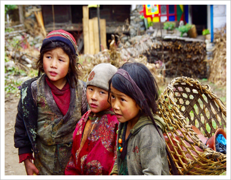
The valley is inhabited by the Tsumbas, a warm and welcoming people. As soon as you enter this valley, you immediately feel transported to another world. The valley is stunning, with its cultivated fields, stone houses, clear, crystalline rivers, vast forests, and the surrounding mountains that rise to over 7,000 meters.

Due to its remoteness and inaccessibility, this sacred valley and its inhabitants remained untouched by development for centuries. The result is a unique and unspoiled culture. The inhabitants have never killed an animal.
A truly forgotten corner of the world!

Highlights

  • A complete Manaslu trek enhanced by exploring the Tsum Valley
  • A valley open to trekkers only since 2008
  • Breathtaking views of Manaslu, Buddha Himal, Himchuli, Sringi Himal, and Ganesh Himal
  • An authentic Tibetan culture
  • A trek off the beaten track
  • A striking contrast between the warm, humid subtropical valleys and the dry northern Tibetan villages

Itinerary

1 Arrival in Kathmandu.
After your visa and customs formalities, baggage claim and you will be met at the airport exit by a representative from the agency. Transfer to the hotel.
2. Transfer by bus to Gorkha (6 hours)
This is the start of an adventure. We depart very early in a private bus to reach Gorkha (1150m), the former capital of the Shah dynasty, located about 100 kilometers from the capital. Leaving the valley, we cross a small pass before plunging down a winding descent to the lower part of the valley, which then runs alongside the Trishuli River. During the season, it's not uncommon to see people rafting. Following the river, we arrive at Mugling, a small town whose appeal lies in its location at a crossroads: the road to India on the left and the road to western Nepal on the right. Continuing on, we reach Abukhaireni, and we leave the main road to turn right towards Gorkha. From Gorkha, we ascend to the fort, the former royal palace of the Shah dynasty. We camp above it in the rice paddies. The hike takes 2 hours.
3 Trek Gorkha (1550m) – Arkhol (500m) 6h
The path follows the Dorandi River through typical fishing villages. After a bridge, we cross to the left bank for a series of ups and downs leading to Arkhol.
4 Trek Arkhol (500m) – Mandre (1100m) 7h
The trail continues to follow the Dorandi River and remains undulating. Subtropical vegetation with banana trees and sugarcane. After Dodani, we cross a suspension bridge. After Rahaul, a final steep climb leads us to Mandre.
5 Trek Mandre (1100m) – Laprak (2300m) 6h
A two-hour climb leads to the large Gurung village of Barpak at 1900m, with its slate roofs. There's a view of Buddha Himal (6672m). The path continues uphill to a pass at 2750m, then descends to another large Gurung village: Laprak.
6 Trek Laprak –Khorla Besi (970m) 6h30
The path descends steeply to cross the Machha Khola (meaning "fish river" in Nepali) on a suspension bridge. On the other side, the path climbs sharply at first, then levels out along the hillside with terraced fields cascading down the slope. Another long descent then leads to Khorla Besi, along the Budhi Gandaki River, which we will follow upstream in the following days.
7 Trek Khorla Besi – Jagat (1350m) 5h30
The trail continues along the right bank, following the Budhi Gandaki upstream, and in an hour we reach Tatopani (meaning "hot water" in Nepali). Many villages in Nepal bear this name due to their hot springs. A suspension bridge allows us to cross to the left bank and ascend to Dobhan, continuing along a pleasant plateau to Shiauli Bhoti. The path then climbs steeply towards Yaruphant, and we return to the right bank after crossing the Yaruphant Khola. The trail then reaches Jagat, the official entry point into the Manaslu area, where a checkpoint is located. We discover our first chorten.
8 Trek Jagat – Lokpa (2240m) 6h
The valley widens slightly, and after crossing a long bridge, we arrive at Philim, situated on a small plateau. We then leave the Manaslu Circuit trail to enter a narrow valley and arrive at Lokpa. Beautiful views of Ganesh, Gyajung Himal, and Sringi Himal.
9 Trek Lokpa – Dumje (2460m) 6h
Le sentier commence en balcon. Nous descendons jusqu’au fond de la vallée et nous traversons les rivières sur des ponts de bois avant de remonter en surplomb du torrent par un sentier en pente raide. Le sentier traverse une épaisse forêt mixte dominée par les pins himalayens. Après une nouvelle traversée de torrent nous arrivons à Dumje.
10 Trek Dumje – Rachen Gompa (3200m) 6h
The trail reaches a bridge over the Shyar Chu, allowing passage to the opposite bank and the ascent to the large village of Chumling. The valley then begins to open up. The trail climbs to Chekam, the gateway to the hidden valley. This village gave its name to the entire Chekampar Valley. We then leave the steep, narrow slopes overlooking the Shiar Khola. Camp near Rachen Monastery.
11 Rachen Gompa – Mu Gompa 3700m
The trail climbs up the wide, cultivated valley and we arrive at Nyile, the village of one of the valley's lamas. Then we reach Mu Monastery, perched like most monasteries. This monastery is located just a few hours from nearby Tibet.
12 Mu Gompa – Chekam 3050m
We descend back down through the valley along the same path we took on the way there to Chekam.
13 to 15 From Chekam to Bihi 3200m
The path continues on Rentsam and
16 Bihi – Namrung 2660m 6h
After crossing the first bridge, we continue on to Ghap and cross the Buri Gandaki River to reach Prok. The path continues to Nambache, and we will have to cross the river twice before finishing with a fairly steep climb to reach the charming village of Namrung.
17 Namrung – Samagaon 3450m 7h
Après le superbe plateau cultivé qui traverse les hameaux de Baksan, Lihi et Wangsang, le sentier arrive à Shyo. Belles vues sur le Ganesh Himal puis sur l’Himal Chuli, suivies d’une série de chortens et de murs à mani intéressants. Le sentier traverse Lho à 3110m avec sa gompa et son école. Belle vue sur le Manaslu. Le chemin monte en forêt jusqu’à Samagaon, gros village aux maisons serrées. Son monastère domine le village.
18 Samagaon – Samdo 3690m 4h
After a morning visit to the monastery and an optional hike to the glacial lake of Birendra Kund, located at the foot of the Manaslu Glacier, we begin an easy walk towards Kermo Manan, a very long mani wall. The alpine-style valley rises gently for this acclimatization day. We cross a small bridge, then the trail climbs steeply but briefly to reach the most beautiful village of the tour: Samdo and its 200 inhabitants. Tibet is very close (3 hours' walk) via the Lajing Bhanjyang pass. The inhabitants of Samdo, all of Tibetan origin, trade regularly with Tibet. We explore this beautiful and very welcoming village.
19 Samdo – Dharamshala 4460m 4h
Ascent to the Dharamshala huts via a balcony trail. It's important to set off early due to the numerous intermittent streams that swell as the sun rises! Lunch at the camp. Afternoon rest to prepare for the pass crossing the next day, or for those feeling fit, a hike in one of the valleys above the camp, chasing after blue sheep. We are at altitude, and hotel infrastructure is limited. The first lodge opened in 2010, and others are sure to follow with the development of tourism in this region. We'll need to be sensible and cheerful this evening. A mountain refuge atmosphere at 4470m.
20 Trek to Bimtang (3600m) via the Larkya La pass (5210m) 8 to 9 hours
An early morning departure. Following a moraine, the path leads to a large glacial lake before opening onto a vast plateau offering stunning views of immense glaciers and the north face of Manaslu. Reaching the pass takes approximately four hours. Breathtaking panoramic views: Samdo Himal (6335m) to the east, Larkya Peak (6249m) to the south, Himlung Himal (7126m), Cheo Himal (6812m), and Ratna Chuli (6767m) to the north, and to the west, Kang Guru (6981m), Annapurna II (7937m), and a multitude of other 6000m peaks, most of them unnamed. After the pass, the trail climbs gently through rocky terrain before plunging down the steep, often snow-covered west face. We pass Larcia at 4700m and then Tabuche Kharka. The trail then joins a lateral moraine near the gigantic glacier descending from the Peri Himal cirque. Arrival on the verdant Bimtang plateau, situated in a cirque surrounded by peaks with sparkling ice. A well-deserved rest in a rustic lodge.
21 Trek to Dharapani (1850m) 7h
A long, varied descent. From the glacial zone, the trail crosses immense forests of gigantic spruce trees, interspersed with alpine meadows. Then, beautiful high-altitude crops appear before reaching the charming village of Tilje, nestled below the gorge… Views of the Manaslu peaks and the Peri Himal massif. The trail rejoins the lush rainforest with giant rhododendrons, lichens, and mosses. The final descent follows the Dudh Khola before joining the Marshyangdi Khola.
22 Trek to Jagat (1290m) 6h30
The trail joins the Annapurna Circuit, with its many visitors. We leave the main path to take you to a hidden village overlooking the valley: Nache. This village resembles a citadel perched atop an improbable cliff and surrounded by fields. Corn, wheat, barley, oats, buckwheat, and amaranth abound, and Asiatic black bears, troops of monkeys, and all sorts of deer descend from the forest, feasting to their hearts' content! After a break, we descend back into the valley and pass through Tal, on the banks of the river that widens into its bed. More descent before crossing at the Chamje bridge at 1410m, where we rejoin the main trail. The hike ends in Jagat.
23 Jeep Jagat – Besisahar, road to Kathmandu
The track is no longer of any interest for trekking and we board jeeps to reach Besi Sahar where our bus is waiting for us for the return journey to Kathmandu.
24th Free day in Kathmandu
This day is dedicated to last-minute shopping or visits to the valley before the return flight the following day.
25 Return flight, airport transfer
Depending on flight times, it will be possible to do some last-minute shopping before heading to the airport for the return flight.

Gallery

You May Also Like --------

Similar Itineraries

8% Off

Ama Dablam Base Camp

US$ 1200/P

US$ 1100/P

22 reviews

From the Annapurnas to Everest

22 reviews

Ama Dablam Base Camp

22 reviews

Everest confort

22 reviews

Everest via the high passes (departure guaranteed on 17/10/2020)

22 reviews

Gokyo Valley – Renjo La

22 reviews

Everest Base Camp by Gokyo

22 reviews

Gokyo-Kongde Lake

22 reviews