Everest via the high passes (in reverse) – guaranteed departure on 17/10/2020

All Inclusive Price

Trip Overview

Level 17/20 17 days of trekking with 10 days above 4,000m and crossing three passes over 5,000m. This region is particularly cold.

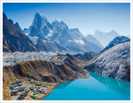
An exceptional journey in the heart of the Khumbu Sherpa, crossing three passes over 5,000m and climbing three peaks over 5,000m, offering panoramic views of the Himalayan giants Everest, Lhotse, Makalu, and Cho Oyu, all rising above 8,000m. Not forgetting the “smaller” peaks like Thamserku, Kangtega, Kwangde, Ama Dablam, Cholatse, Tawoche, Island Peak… Prestigious names that you can associate with the mountains surrounding you! An exceptional but very challenging itinerary in a cold region, with nine days above 4,000m. Over seventeen days of trekking, the circuit follows the Dudh Kosi River upstream to Namche, the horseshoe-shaped capital of the Sherpa country. From there, you ascend to Thengboche Monastery and continue north to Chukung, the last village offering lodges. From Chukung Ri, you’ll reach your first summit before crossing your first pass the following day: the Khongma La, which leads to the glacier’s moraine towards Lobuche. Next, you’ll climb Kala Patthar, a superb viewpoint overlooking Everest. A short detour to Everest Base Camp precedes the descent to Dzonghla. You’ll then cross the second pass, the Cho La, easier from this side, before descending to Gokyo and its turquoise lakes. Finally, you’ll climb Gokyo Ri, your third peak over 5,000 meters, with Cho Oyu as a backdrop. You still have to cross the last pass, the Renjo La, before descending into the valley leading to Thame. Then you descend to Namche, the capital of the Sherpa country, and to Lukla, the return point for your flight to the capital.

Highlights

  • Unique panoramas of four 8,000-meter peaks
  • A visit to Everest Base Camp
  • An original, large-scale circuit allowing for easier crossing of the
  • Choa pass in this direction
  • Gokyo and its turquoise lakes
  • A truly high-mountain atmosphere

Itinerary

1 Arrival in Kathmandu.
After your visa and customs formalities, baggage claim and you will be met at the airport exit by a representative from the agency. Transfer to the hotel.
2 Flight from Kathmandu to Lukla (2850m).
A 40-minute flight in a Twin Otter from Kathmandu to Lukla, the gateway to the Khumbu region. We meet our local staff at the airport exit, and after a brief introduction and the distribution of loads among the porters, the trek begins. Trek to Phakding (2600m). 3 hours +100m -300m The trail crosses Lukla along the main street lined with lodges and shops, and at the edge of the village, begins a steep descent towards a river with Kusum Kanguru (6367m) as a backdrop. The path then climbs slightly, skirting a ridge to reach Ghat on the banks of the Dudh Kosi River, the "milk river" due to its whitish color. The trail then follows a series of typical Nepalese ascents and descents before finally arriving in Phakding.
3 Trek Phakding – Namche Bazar (3440m). 6h + 820m – 40m
The trail continues north up the Dudh Kosi valley, climbing through cultivated fields to Benkar with its enormous carved boulder in the middle of the path. The trail then continues its ascent through a wooded area of ​​rhododendrons, magnolias, and fir trees. Soon, Mount Thamserku comes into view, and we enter Sagarmatha National Park at Jorsale. Crossing a suspension bridge high above the confluence of the Dudh Kosi and Bhote Kosi rivers, the trail continues a long and steep climb to a ridge offering views of the Everest, Nuptse, and Lhotse peaks. The trail continues its ascent through the forest to Namche, a protected settlement nestled in a natural amphitheater.
4. Acclimatization around Namche Bazaar (3440m). 4 hours
Given the significant altitude gain and the fact that the following days will take us even higher, this day is dedicated to acclimatization. Optional activities include either rest and strolling through the bazaar with its shops reminiscent of Thamel, or a hike in the hills to visit the villages of Shyangboche and its small airstrip, as well as the Kunde hospital.
5 Trek Namche Bazar – Thengboche (3840m). 4h + 580m – 160m
We set off on a wide path that leads us to the edge of Namche. At the top of the climb, the peaks unfold one after another: Thamserku, Kangtaiga, Ama Dablam, Lhotse Shar, Tawoche… The path continues to ascend, passing stones engraved with mantras at Sanasa, a small hamlet inhabited by Tibetans. The trail descends steadily to Teshinga, then more steeply to Phunki Thangkha at 3250m, a small hamlet with numerous prayer wheels powered by the waters of the Dudh Kosi. After a picnic lunch, the path resumes its steep climb, then becomes more gradual as it winds through the forest along the hillside to a plateau at the summit where the Thengboche monastery stands, nestled in a clearing surrounded by rhododendrons and dwarf firs. From this point the view is fantastic: Kwangde (6187m), Tawoche (6542m), Everest (8848m), Nuptse (7855m), Lhotse (8616m), Ama Dablam (6856m), Kangtega (6779m) and Thamserku (6608m).
6 Tengboche – Dingboche (4410m). 4h + 660m – 110m
After an early start to a stunning panorama of the Earth's giants, the trail makes a short but steep descent through a forest of birch, conifers, and rhododendrons to Devuche. Due to the hunting ban, it's not uncommon to see pheasants along the path. The trail passes a series of mani walls in a dense rhododendron forest. We cross the Imja Khola River on a very high metal bridge over the turbulent waters of this torrent as it rushes through a narrow fissure. After the bridge, the trail climbs alongside magnificent mani walls to reach Pangboche at 3860m. The trail then enters the alpine zone at the tree line. The vegetation consists of juniper bushes. The path passes Shomare and Orsho, then splits in two: the better-defined and lower track leads to Dingboche.
7 Trek Dingboche – Chhukung (4750m). 2h30
Today is a very leisurely day, hiking up the Imja Khola valley to Chhukung, the last hamlet with lodges. The south face of Lhotse dominates the landscape. For the more adventurous, there's the option of heading towards Island Peak base camp.
8 Ascent of Chhukung Ri (5550m) – Return to Chhukung (4750m). 5h + 800m – 800m.
On the agenda for today is the first of three peaks, Chhukung Ri. The climb is not technical and requires no special equipment. The panorama is spectacular, overlooking the Nuptse and Lhotse glaciers. Return via the same route to Chhukung.
9 Khongma La (5735m) – Lobuche (4910m). 7h + 880m – 720m
An early start is necessary, following a grassy path leading to a plateau before the ascent, which offers superb views of the surrounding peaks throughout. A small lake lies below the pass before the final steep section. The view of Makalu, Ama Dablam, and especially the immense barrier of Lhotse and Nuptse is truly breathtaking! 3,000 meters of vertiginous faces tower above us; and we are at 5,550 meters… The descent is through a scree slope, steep at first, which then eases. Crossing the Khumbu Glacier opposite Lobuche, surrounded by a multitude of gigantic towers that shimmer in the sun, it is sometimes necessary to find the way. It is possible to descend via Dingboche for those who wish.
10 Lobuche (4910m) – Gorakshep (5140m) Kala Pattar (5543m). 6h + 700m – 470m
The trail begins by following the west bank of the wide Khumbu Valley, climbing steadily through pastures alongside the glacial moraine. The ascent then becomes steeper and more challenging as it traverses several lateral moraines. The path curves, and Pumori (7,161 m), the "daughter's mountain," appears in its distinctive conical shape. The trail then descends slightly onto a flat, sandy expanse near Gorakshep. The ascent of Kala Pattar is the highlight of the trek. It's a steep climb up grassy slopes west of Gorakshep to a promontory at the foot of Pumori, from where the entire south face of Everest is visible, as well as the Lho La pass (between Tibet and Nepal), Changtse, and most of the west ridge.
11 Gorakshep Trek – Everest Base Camp (5360m) – Lobuche (4910m). 6/7h + 250m – 480m.
The path to base camp follows the Khumbu Glacier, sometimes along the moraine, sometimes on the glacier itself. The route is long but magnificent, leading to the inhospitable Everest Base Camp: a place as mythical as it is uncomfortable, where summiters remain for several weeks. Views of the Icefall, an enormous serac, and the route to the South Col. Return via the same path to Gorakshep and then Lobuche. The sunset over nearby Nuptse will remain an unforgettable memory.
12 Trek Lobuche (4910m) – Dzonghla (4830m). 2h + 150m – 230m
Today is a recovery day before crossing the Cho La pass tomorrow, but still in a high mountain environment. The balcony trail overlooks a small lake. The peaks of Tawoche and Cholatse dominate the landscape, as does Ama Dablam.
13 Trek – Dzongla (4830m) – Cho La (5420m) – Dragnak (4700m). 6h + 550m – 680m
Today's route involves crossing the second pass, which leads down into the Gokyo Valley. The trail initially follows a stream before entering a rocky section. The path then levels out and traverses a few rocky slabs before reaching a glacier on the eastern side of the pass. The descent continues across a scree slope and then through two former glacial valleys, now bare, separated by a moraine. This leads to the hamlet of Dragnak.
14 Gokyo Lakes Trek – Gokyo Ri Ascent (5357m) – Gokyo (4790m) 5h + 750m – 600m
We need to cross the Ngozumpa Glacier. It originates from the south face of nearby Cho Oyu and fills the entire valley for nearly 17 km. We descend to a cairn-marked passage that allows us to safely cross a 1.5 km wide jumble of rocks. From there, we simply reach Gokyo, a stunning spot on the shores of the lakes. To fully appreciate the breathtaking panorama, we undertake the two-hour ascent of Gokyo Ri, and at the summit, we are rewarded with views of Cho Oyu, Gyachung Kang, Everest, Lhotse, Makalu, Cholatse, and Tawoche. We then descend back to the lake and take a stroll around Gokyo.
15 Gokyo Lakes Trek – Renjo La (5360m) – Lungdeng (4380m). 6/7h + 600m – 1010m
Today we will cross our last pass: the Renjo La. The trail runs alongside the lake, and the ascent is a series of steep sections and flatter stretches. At the pass, the view of the Everest massif is exceptional. In a single glance, we take in all the peaks of the Kumbu region, including, from left to right, four of the fourteen highest peaks on the planet: Cho Oyu, Everest, Lhotse, and Makalu… The first part of the trail follows a staircase that winds through a steep scree slope. This section can be tricky if there is snow… At around 4,500 meters, we emerge onto a sandy area. We pass a few small lakes before arriving at Lungdeng.
16 Trek Lungdeng (4380m) – Thame (3800m). 3h + 200m – 780m
The trail continues its descent along the left bank of the Bhote Kosi River through alpine meadows and passes through the village of Marulung at 4210m. We cross to the other side via a bridge as the descent continues, and we must cross a tributary before reaching Taranga. A kilometer further on, we cross another stream and, still on the right bank, arrive at Thame. This route is used by Sherpas who trade with Tibet via the Nangpa La pass, and it is not uncommon to encounter yak caravans. Thame is the village where some of the great Sherpas who climbed Everest, such as Ang Rita and Appa, were born.
17 Trek Thame – Namche Bazar (3440m)4h
The trail leaves the village, descending towards the river, which we cross on a bridge before climbing back up the other side. The path passes through Samde at 3610m and then descends towards Thamo amidst alpine meadows. A short stop at the checkpoint, and the trail is clearly above the river. The Kwangde massif is magnificent. We pass through the hamlets of Samshing, Phurte, and Gangla, traversing forests of pine and rhododendrons. We arrive back at Namche Bazaar, the capital of Sherpa country, with its bustling alleyways.
18 Trek Namche – Lukla (2850m) 6h
The route follows the same path as the outward journey, with a steep descent to the confluence bridge. From there, it's along the left bank of the Dudh Kosi to Jorsale, where we show our permits at the checkpoint. The descent continues to Monjo, crosses the Monjo Khola on a bridge, and then the path continues to the right bank of the Dudh Kosi before Benkar. Before Phakding, the path crosses back to the left bank and continues downhill to Ghat and Cheplung. From this village, the path climbs steeply to the entrance of Lukla.
Flight 19 Lukla – Kathmandu
Early in the morning, we head to the airport for a 40-minute return flight on a Twin Otter to the capital. Planes come and go, bringing in new trekkers, supplying hotels, and taking trekkers back down. Back to the hustle and bustle of the capital, we transfer to the hotel for a nice hot shower.
20 Kathmandu Valley
Today we set off to explore the Kathmandu Valley, starting with the charming city of Bhaktapur, "the city of devotees," the jewel of the valley with its countless temples and scenes of rural life. After lunch, we return to Kathmandu, visiting the Hindu shrine of Pashupatinath, where all Hindus are cremated. Then we continue to the enormous Buddhist stupa of Bodhnath, where Tibetan pilgrims tirelessly circle the stupa, spinning prayer wheels and reciting their rosaries. What an atmosphere!
21 Departure from Kathmandu
Depending on flight times, it will be possible to do some last-minute shopping before heading to the airport for the return flight.

Gallery

You May Also Like --------

Similar Itineraries

8% Off

Ama Dablam Base Camp

US$ 1200/P

US$ 1100/P

22 reviews

The Arkhol Tshum Valley

22 reviews

From the Annapurnas to Everest

22 reviews

Ama Dablam Base Camp

22 reviews

Everest confort

22 reviews

Everest via the high passes (departure guaranteed on 17/10/2020)

22 reviews

Gokyo Valley – Renjo La

22 reviews

Everest Base Camp by Gokyo

22 reviews